

In October this year Raj will be setting off on the trip of a lifetime – he’s doing the Everest Base Camp trek. This is something that has been on his bucket list his whole life and it’s something that just a few years ago we thought might not be possible at all. Yet, here we are, Raj is training and preparing every day to be fit and ready to make the two week journey to one of the highest points in the world.
We will, of course, be sharing loads more details about his Everest Base Camp trekking journey once he’s back. But to get us started we thought we would share with you the itinerary for the trek.
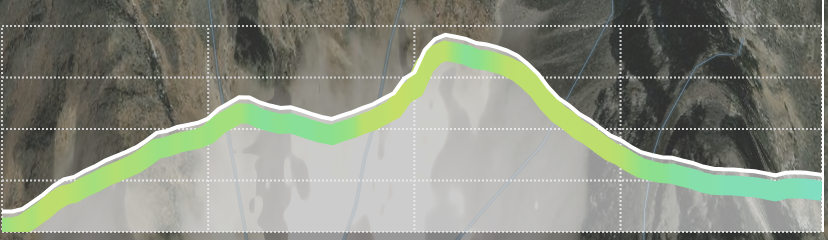
 Photo by I Do Nothing But Love on Unsplash
Quick Links To Information In This Post
Everest Base Camp and Gokyo Lakes Trek
Raj will be going on the the trek to Everest base camp via the Gokyo Lakes in Nepal.
His itinerary includes heading out to Kathmandu early so he can acclimatise to the higher altitude, get over any jet lag, explore the city, and get to celebrate Diwali there.
This particularly Everest Base Camp trek follows the lesser travelled route via the Gokyo Lakes. Raj’s expedition will be travelling from Lukla to Phakding and then onto Namche Bazaar like many other tour groups.
After an acclimatisation day in Namche Bazaar the group will head towards Phortse Thanga. Then it is a trek on towards Marchermo and then Gokyo. At Gokyo the Gokyo Lakes are the world’s highest freshwater lake system at an elevation of between 4,700-5,000m. There will be another acclimatisation day at Goyko.
The next part of the trek is from Gokyo, up Gokyo Ri, across the Ngazumpa Glacier and onto Thagnak. After that is one of the toughest days, taking the Cho La Pass from Thagnak to Dzongla.
From Dzongla the expedition hikes to Lobouche. And then finally, on the next day, the trek takes them to Gorak Shep and onto Everest Base Camp. If there’s time they will also hope to climb Kala Patthar, a 5,550m summit with amazing views of the mountains including Mount Everest.
After a stay in Gorak Shep, the next morning the group will get a helicopter down to Lukla, taking in the stunning scenery before getting a flight from Lukla to Ramechhap and a bus back to Kathmandu.
The change of departure flight from Kathmandu to Ramechhap in 2022
This year the policy in Nepal is that all flights to Lukla will now be departing from Ramechhap airport instead of Kathmandu airport. So the tour group will be getting transport from Kathmandu to Ramechhap then flying onto the Lukla.
It seems this policy aims to reduce aiport traffic at Kathmandu airport and should make flights more reliable when there are weather changes.
The flight from Ramechhap to Lukla will be 12 minutes long.
Everest Base Camp Trek 2022 Itinerary
Day 1: Kathmandu to Ramechhap
Transport from Kathmandu to Ramechhap. Possibly an overnight stay there. This is still to be confirmed in detail with the expedition company.
- ELEVATION: 1,400m
- ELEVATION GAIN: n/a
- TREK DISTANCE: n/a
- OXYGEN LEVEL: 85%
ELEVATION GRAPH: n/a
Day 2: Ramechhap to Lukla to Phakding
We leave early for a transfer to Ramechhap for our morning flight into Lukla, from where we begin our trek into the Khumbu region.
The views from the plane are amazing, providing dramatic scenes of terraced hills and the distant Himalayan giants.
After landing we meet our ground crew and begin a 3 to 4 hour trek to Phakding (2,610m), our night’s resting place.
- ELEVATION: 2,860 – 2,610m
- ELEVATION GAIN:↑199m ↓406m
- TREK DISTANCE: 7.8km
- OXYGEN LEVEL: 73-74%
ELEVATION GRAPH:
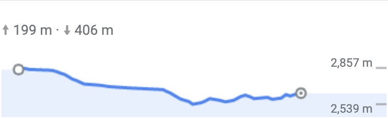 Lukla to Phakding Elevation Gain
Day 3: Phakding to Namche Bazaar
Walking through a beautiful pine forest, we follow the trail north up the valley of Benkar.
We trek along the banks of the Dudh Kosi, cross roaring rivers on exciting suspension bridges.
As we enter the Sagamartha National Park, we begin to climb with breathtaking views to Namche Bazaar, the gateway to the Khumbu region.
After a full days trekking we rest for the night in Namche Bazaar.
- ELEVATION: 2,610-3,440m
- ELEVATION GAIN: ↑1,069 m ↓292 m
- TREK DISTANCE: 7.4km
- OXYGEN LEVEL:74-64%
ELEVATION GRAPH:
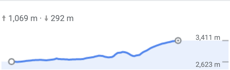 Phakding to Namche Bazaar Elevation Gain
 Photo by Kalle Kortelainen on Unsplash
Day 4: Acclimatisation Day in Namche Bazaar
Today we rest and acclimatise in Namche Bazaar. Namche is the Sherpa capital and a bustling village crammed with markets and traditional Sherpa houses.
We take an early morning hike to the Sherpa museum where we see views of Mt. Everest, Mt. Lhotse (the 4th highest peak in the world) and the beautiful Mt. Ama Dablam.
The Sherpa Museum houses an exhibit of traditional Sherpa lifestyles and a fabulous photography display.
The rest of the day is for private exploration of this enchanting place.
- ELEVATION: 3,440m
- ELEVATION GAIN: n/a
- TREK DISTANCE: n/a
- OXYGEN LEVEL: 64%
ELEVATION GRAPH: n/a
Day 5: Namche Bazaar to Phortse Tenga
We climb the Khumjung hill and descend to the east of the village down the broad valley leading to the Dudh Koshi river from where the route turns north.
We visit Mohang, the birthplace of the re-incarnated Lama of Rongbuk Monastery of Tibet who is believed to have introduced Buddhism in the Khumbu region of Nepal.
The trail descends in a series of steep switchbacks down a sandy slope to the Dudh Koshi. We stay overnight in Phortse Tenga, near the river.
- ELEVATION: 3,440-3,840m
- ELEVATION GAIN: ↑632 m ↓450 m
- TREK DISTANCE: 5.7km
- OXYGEN LEVEL: 64-62%
ELEVATION GRAPH:
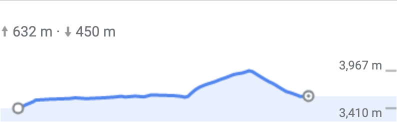 Namche Bazaar to Phortse Thanga Elevation Gain
Day 6: Phortse Thanga to Machhermo
From Phortse Thanga it is an uphill climb to Machhermo.
We walk on a trail alongside a rhododendron forest and pass through a waterfall before reaching Tongba Village.
We continue our uphill trek and pass through Dhole, Labarma and Luza villages before reaching Machhermo.
There is a Chorten (stupa) right before the Luza village.
Throughout today’s journey we will be walking alongside the Dudh Koshi river. Overnight in Machhermo.
- ELEVATION: 3,840-4,470m
- ELEVATION GAIN: ↑630m
- TREK DISTANCE: 7.3km
- OXYGEN LEVEL: 60-57%
ELEVATION GRAPH:
 Phortse Thanga to Macchermo Elevation Gain
 Photo by Chinh Le Duc on Unsplash
Day 7: Machhermo to Gokyo
We begin today by climbing a ridge for an excellent view down the valley to Mt. Kangtaiga (6,782 m) and also up towards Mt. Cho Oyu (8153 m – 6th highest mountain in the world).
The valley now widens and we descend to the riverbank before climbing onto the terminal moraine of the Ngazumpa Glacier on a steep trail.
Upon crossing an iron bridge over a stream, the trail levels out as it follows the valley past the first lake, known as Lake Longpongo, at 4690 m.
At the sight of the second lake, Lake Taboche Tsho, we become mesmerised by the shimmering turquoise blue sheet of water sparkling in the sun.
Gokyo village stands by the third lake and Cho-Oyu mountain as a backdrop sets an amazing spectacular view.
After lunch, we explore around the third lake, Lake Dudh Pokhari. We spend the night in Gokyo.
- ELEVATION: 4,470-4,750m
- ELEVATION GAIN: ↑406 m ↓30 m
- TREK DISTANCE: 6.8km
- OXYGEN LEVEL: 57-55%
ELEVATION GRAPH:
 Machhermo to Gokyo Elevation Gain
Day 8: Gokyo Valley: Acclimatisation Day with an optional hike to 4th and 5th Lakes
We can spend this day taking a rest in the Gokyo Valley or hike to some additional lakes – Lake Thonak Tsho and Lake Ngozumba Tsho.
If we want to, we can climb a hill, also called the Scoundrel’s Viewpoint, which is located at the edge of Lake Ngozumba Tsho. From here we get astounding views of Mt. Cho-Oyu, Mt. Gyachung Kang, Mt. Everest, Mt. Lhotse, Mt. Nuptse, and Mt. Makulu mountains. From here, we also see the Cho Oyu base camp. Another treat for us is the view of the biggest glacier of the world- the Ngozumba Glacier.
We trek back to Gokyo and spend the night.
- ELEVATION: 4,750m
- ELEVATION GAIN: n/a
- TREK DISTANCE: (depends on whether they do the optional hike)
- OXYGEN LEVEL: 55%
ELEVATION GRAPH: n/a
Day 9: Gokyo to Thagnak
Today we can climb Gokyo Ri.
Climbing to the top is fairly demanding (3-4 hours), but the scenery of Gokyo village, on the edge of third lake overlooked by Mt. Cholatse (6,440 m) the broad Nogzumpa Glacier, is magnificent.
We are surrounded by panoramic mountains like Kusum Kanguru, Thamserku, Kangtega, Taboche, Cholatse, Makalu, Lhotse, Nuptse, Everest, Changtse, and Pumori. The sight of sunrays kissing Everest which towers over all the surrounding peaks is astounding.
We trek through the Ngazumpa Glacier to the mountain on the other side.
Next, traverse along the edge of that mountain and then meander into Thagnak.
It will be a short hike today to our next stop with an afternoon of rest which will prepare us for long hiking days and elevation gain to come.
- ELEVATION: 4,750m – 5,338m – 4,676m
- ELEVATION GAIN: ↑603 m ↓686 m
- TREK DISTANCE: 6.7km
- OXYGEN LEVEL: 55%
ELEVATION GRAPH:
 Gokyo Ri and to Thagnak Elevation Gain
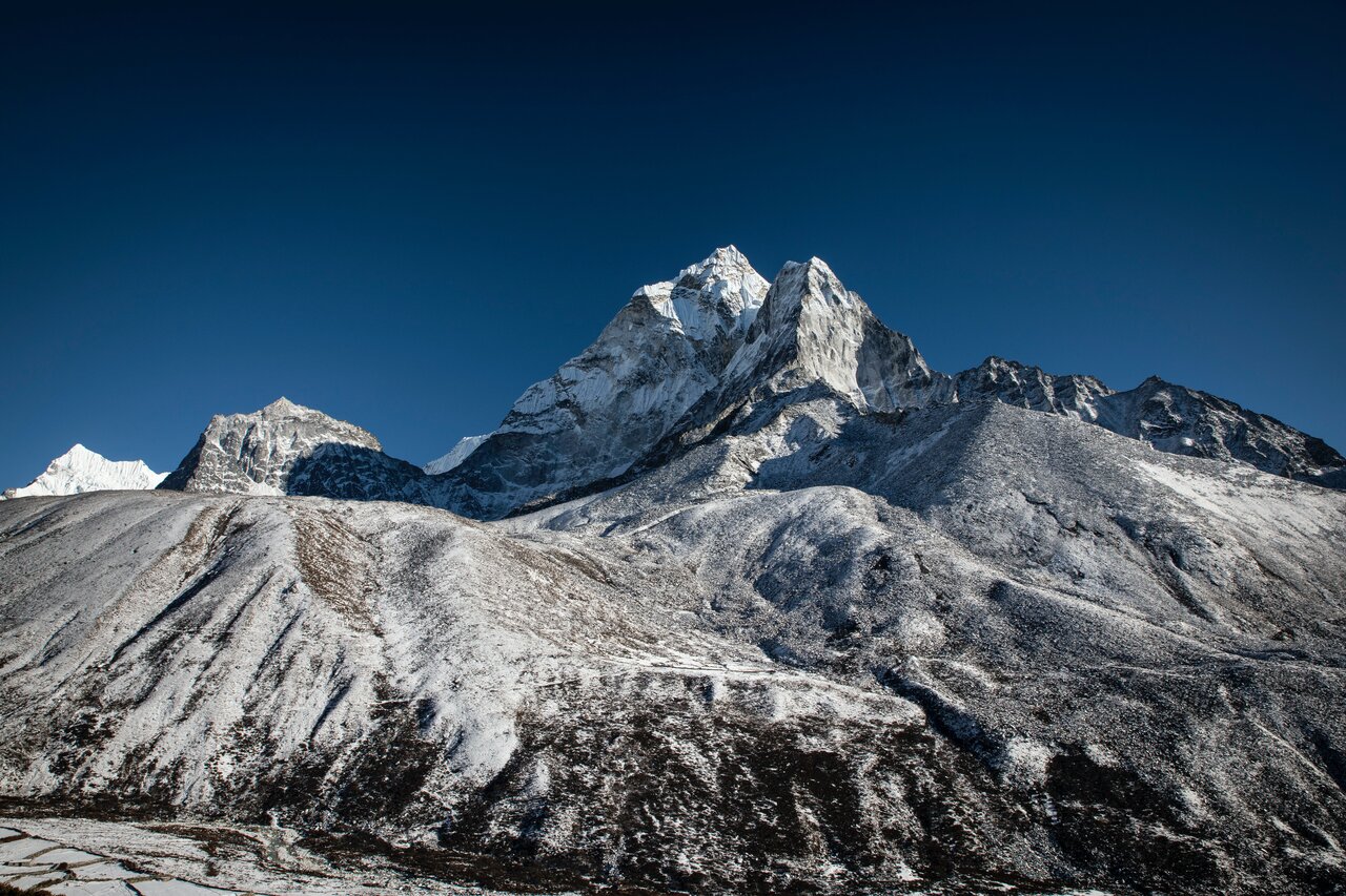 Photo by Kerensa Pickett on Unsplash
Day 10: Thagnak (Cho La Pass) to Dzongla
Today is going to be one of the toughest days of the trip.
The Cho La pass is not itself difficult, but the terrain is steep and includes a glacier traverse on the eastern side.
We are rewarded at the top of the pass with an array of prayer flags and spectacular views – the pyramidal Mt. Ama Dablam, Mt. Cholatse, Mt. Lobuche East and Mt. Baruntse.
We need to pass through some broken terrain before we reach Dzongla Village. The village provides great views of these mountains along with the Pheriche Village far below. Overnight in Dzongla.
- ELEVATION: 4,750-4,830m
- ELEVATION GAIN: ↑784m ↓642m
- TREK DISTANCE: 8km
- OXYGEN LEVEL: 50%
ELEVATION GRAPH:
 Thagnak to Dzongla via Cho La Pass
Day 11: Dzongla to Lobuche
This will be a very short trek so we have a lot time to relax and enjoy the beauty that surrounds us.
We climb down from Dzongla and walk through a grassy trail while enjoying the view of Lobuche Peak.
The trail curves through the wide river bed before reaching Lobuche.
We can spend the rest of day taking a rest which will help us prepare for the next day’s long trek. Overnight in Lobuche.
- ELEVATION: 4,940m
- ELEVATION GAIN: ↑216m ↓119m
- TREK DISTANCE: 6.5km
- OXYGEN LEVEL: 55%
ELEVATION GRAPH:
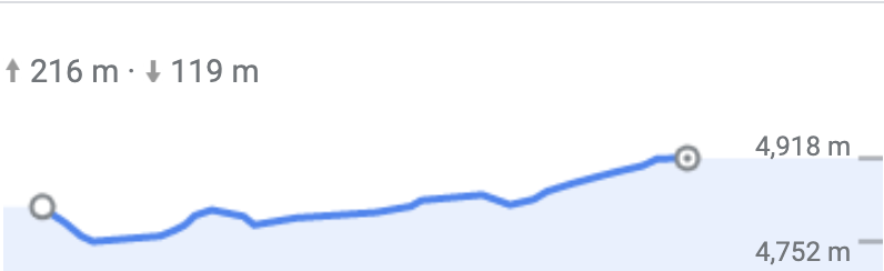 Dzongla to Lobuche elevation gain
Day 12: Lobuche to Gorak Shep, visit Everest Base Camp
We take the trail to Everest Base Camp through the once vast Gorak Shep Lake. The walk is strenuous due to thin air in the high altitude. We pass through rocky dunes, moraine and streams before reaching the Everest Base Camp and a sea of tents.
Mt. Nuptse, Mt. Khumbuste and Mt. Pumori are the mountains we can view from the base camp.
We get back to Gorak Shep for a good night’s rest. Overnight in Gorak Shep.
Depending on timings, we may have the opportunity to ascend the non-technical hill Kala Patthar (5,550m) – if we do, we’ll be rewarded for our efforts with stunning views of the summit of Mount Everest, Mt. Nuptse, Mt. Lhotse and Mt.Ama Dablam.
- ELEVATION: 5,170 – 5,364m
- ELEVATION GAIN: ↑546m ↓309m
- TREK DISTANCE: 11.1km
- OXYGEN LEVEL: 52-50%
ELEVATION GRAPH:
 Lobuche to Gorak Shep via Everest Base Camp elevation gain
Day 13: Gorak Shep to Lukla to Kathmandu
We’ll meet the helicopter crew in the early morning, and enjoy a scenic flight with incredible views over Mt. Kala Patthar and the Khumbu ice fall before flying back to Lukla.
We’ll then transfer to a smaller twin prop plane and fly from Lukla back to Ramechhap then a drive back to Kathmandu.
- ELEVATION: 5,364 – 2,800m
- ELEVATION GAIN: n/a
- TREK DISTANCE: n/a
- OXYGEN LEVEL: 52-73-85%
ELEVATION GRAPH: n/a
Everest Base Camp via Gokyo Lakes Trek Map
Below we’ve made a quick map with the main stops of the trek.
 EBC via Gokyo Trek Map
Check back soon for more updates on Raj’s preparations and trek to Everest Base Camp.